1. 简单入门
2. BOSGeo前端介绍
面向BIM应用的三维GIS数据存储、管理、分享和开发平台,为城市基础设施提供基础数据服务 —— 给建筑一个地理环境,给地理环境更多真实建筑。
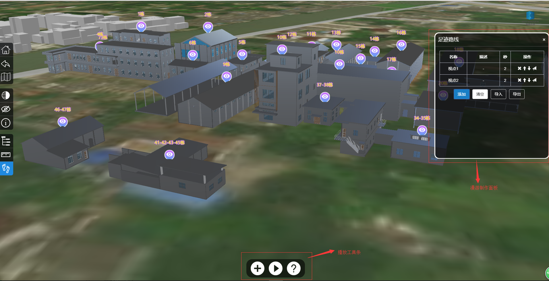
BOSGeo展示效果如图所示
3. BIM转Geo数据基本流程
3.1. 第一步:上传BIM模型
可以在bos,bos3d或数字建筑物中上传模型,上传模型后,能够得到bos3durl,modelDb,modelKey
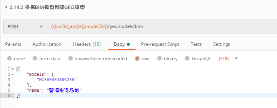
3.2. 第二步: BIM转Geo模型数据
根据BIM模型创建GEO模型,即将bim数据转化为3dtiles数据
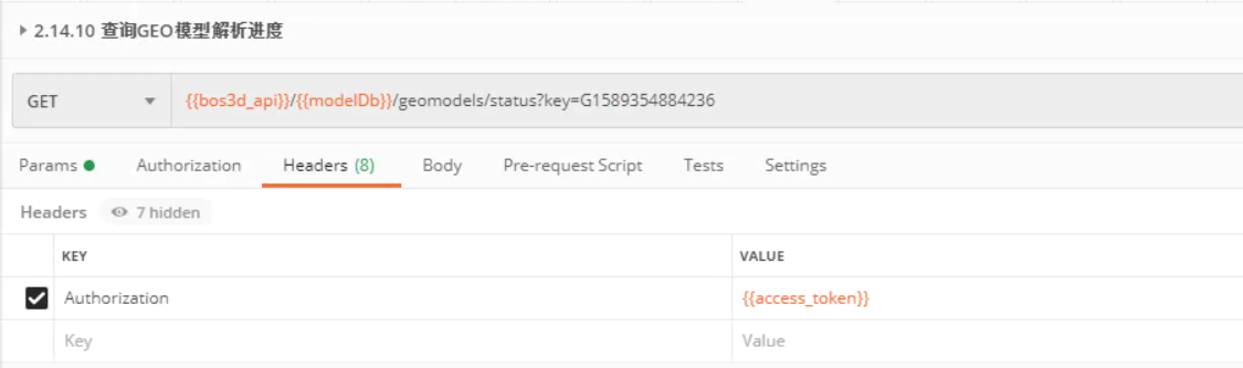
3.3. 第三步: 查询Geo模型解析进度
根据BIM模型创建GEO模型,即将bim数据转化为3dtiles数据
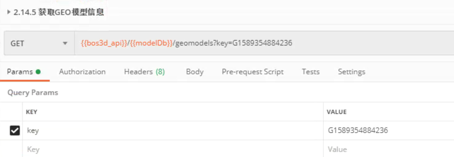
3.4. 第四步: 获取Geo模型信息
根据BIM模型创建GEO模型,即将bim数据转化为3dtiles数据
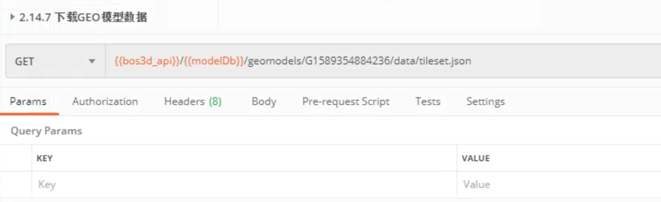
3.5. 第四步: 验证Geo模型数据
原始请求格式为:{bos3dAPI} /{databaseKey}/geomodels/{key}/data/{url} 其中url即为上一个请求中的mainPath,模型数据的主文件
4. 前端展示Geo数据基本流程
4.1. 第一步:html页面
<div id="mapContainer" style="width: 1000px; height: 800px;"></div>
4.2. 第二步: 引入依赖文件
<link rel="stylesheet" href="http://model.rickricks.com:7780/static/BOSGeo/BOSGeo.css" />
<script type="application/javascript" src="http://model.rickricks.com:7780/static/BOSGeo/BOSGeo.js"></script>
4.3. 第三步: 编写初始化代码
var map = new BOSGeo.Map('mapContainer', {
    mapType: BOSGeo.GD_VECTOR
});
4.4. 第四步: 加载模型
var layers = map.layers;
var modelCollection = new BOSGeo.LayerCollection({
    name: '模型集合',
    type: 'model'
});
layers.add(modelCollection);
modelCollection.add(new BOSGeo.ModelLayer({
    name: '测试',
    type: '3dtiles',
    url: './G1595408695930/tileset.json',
    position: [113.10753420284743, 23.03054599944751, 20],
    enableCache: true,
}));
5. 示例demo代码
特别说明: 下面示例代码中url 使用 “验证Geo模型数据” 这一步的地址。
<!doctype html>
<html>

<head>
  <meta charset="utf-8">
  <meta http-equiv="X-UA-Compatible" content="IE=edge">
  <meta name="viewport" content="initial-scale=1.0, user-scalable=no, width=device-width">
  <link rel="stylesheet" href="http://model.rickricks.com:7780/static/BOSGeo/BOSGeo.css" />
  <title>加载模型</title>
  <style>
    html {
      font-size: 12px;
    }

    html,
    body,
    #mapContainer {
      height: 100%;
      width: 100%;
      padding: 0;
      margin: 0;
    }

  </style>
</head>

<body>
  <div id="mapContainer"></div>
  <script src="http://model.rickricks.com:7780/static/BOSGeo/BOSGeo.js"></script>
  <script>
    var map = new BOSGeo.Map('mapContainer', {
    mapType: BOSGeo.TDT_IMAGERY,
    enableHighlight: true // 是否高亮选中的模型
    });
    // 获取图层管理类
    var layers = map.layers;
    // 设置收集模型的集合
    var modelCollection = new BOSGeo.LayerCollection({
    name: '模型集合',
    type: 'model'
    });
    // 将集合添加到图层管理中
    layers.add(modelCollection);

    var tiles = new BOSGeo.ModelLayer({
    name: '油罐4',
    type: '3dtiles',
    url: 'http://canyou.rickricks.com:8093/G1578458793946/tileset.json',   //这里url使用“验证Geo模型数据”这一步的地址
    position: [121.46517, 31.16734, 3],
    rotation: [0, 0, 0],
    enableCache: true,
    scale: 1,
    // onClick: layer => {
    //     layer.zoomTo();
    // },
    loaded: tileLoaded
});


map.viewChange.addEventListener((position, rotation) => {
  // position = 相机视角的数据 = [经度,纬度,高度]
})
modelCollection.add(tiles);
function tileLoaded (tileset) {
    // var axis = new BOSGeo.MeasureAxis({model: tileset, x: false, width: 1, alpha: 0.1});
    // axis.showAxis(); // 添加坐标轴
    // axis.showCube(); // 添加包围盒
    map.flyToEntity(tileset, {duration: 1.6});
}
  </script>
</body>

</html>